Water temperature measured in °C
RED: Maximum in the last 24 hours
BLACK: Current value
ORANGE: Snapshot taken 6 hours ago (-6H)
BLUE: Minimum in the last 24 hours
Sea level
Sea level measured in cm
RED: Maximum in the last 24 hours
BLACK: Current value
BLUE: Minimum in the last 24 hours
Time (UTC)
Sea Level (cm)
Sea Temperature (°C)
No data available
Calypso South Meteo marine station of Capo
Granitola (Sicily)
Description of the monitoring system for
Western Sicily
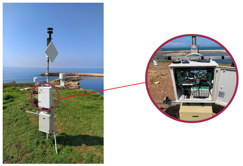
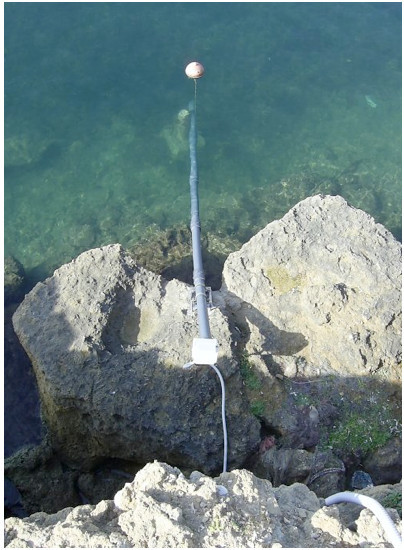
Figure 1: Installation of the Marine Weather Station of Capo
Granitola A) Pole with control unit and weather sensors,
B) Sea level and temperature sensors.
One of the two monitoring system for the Trapani
area of the Mediterranean Channel was installed
in the small harbour of Torretta Granitola (TP,
western Sicily), inside the CNR headquarters. This
is a meteo marine station able to acquire continuously
both meteorological parameters and sea level and
water temperature. A first version of this
monitoring system was born in 2007 with the
Project "Creation of a prediction station for
Marrobbio events to be installed in the fishing
port of Mazara del Vallo" (Project code
1999.IT.16.1.PO.011 / 4.17 b / 8.3.7 / 0082
sub-measure 4.17 b POR Sicily 2000-2006 Axis 4 -
Local Development Systems) approved and financed
by the Regional Councilorship for Cooperation,
Commerce, Crafts and Fishing. This installation
has been updated and upgraded thanks to the Interreg
Italia-Malta Calypso South – Project (Extending
Data and Services for Safer Navigation & Marine
Protection).
In addition to the traditional weather parameters,
the system with the Mazara station is able to
monitor the passages of the atmospheric pressure
fronts. In fact, certain atmospheric turbulences
can often contribute to the formation of local
and/or synoptic-scale meteo-tsunami phenomena,
often dangerous for the population and known
locally with the name of "Marrobbio". This phenomenon
is also often present in the Torretta Granitola
zone and therefore, monitoring these parameters
can help us prevent risks, especially during
docking maneuvers and approaches to the small port
of Capo Granitola.
The updating and upgrading activities of this Meteo
Marine Station were co-ordinated by Dr. Salvatore
Aronica, Scientific Responsible for CNR partner
in the Calypso South Project. The staff project
is composed by: Dr. Giacalone Giovanni, Dr. Ignazio
Fontana, Dr. Angelo Bonanno, Dr. Gualtiero Basilone,
Dr. Simona Genovese, Dr. Salvatore Mazzola, Dr.
Evelyn Scicchigno, Sig. Pietro Calandrino, Dr.
Alessio Langiu, Dr. Antonio Bonanno and Dr.
Salvatore Mazzola.
The meteo marine station installed in Torretta
Granitola provide high-quality, standardised data
and it is a part of the Calypso-South network of
Meteo-marine stations.
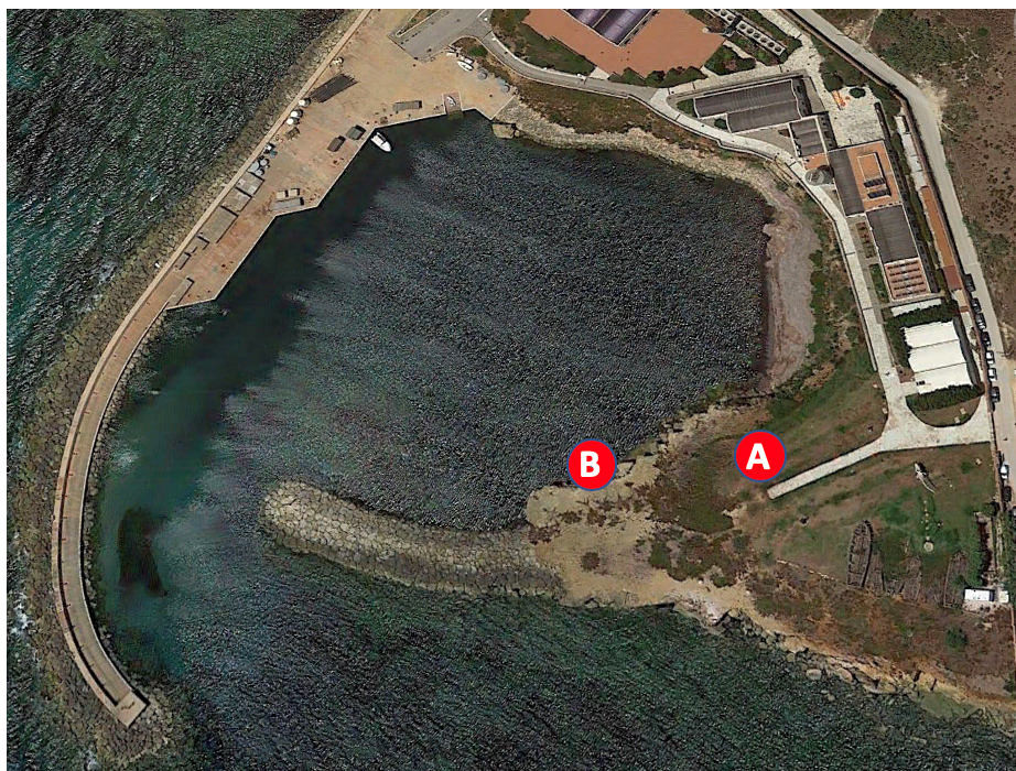
The Capo Granitola Meteo Marine station was
installed mainly in a single location inside the
small port of Capo Granitola on an embankment
facing the sea (position A in figure 1) at about
10m above sea level with the following coordinates
37°34'.16N 12°39'.33 E. The sea level and
temperature sensors, are installed in water at a
depth of about 1.5 meters protected by a thick
PVC housing (position B in figure 1). The sensors
in the water are about 50 m away from the pole
where the acquisition control unit is installed.
Figure 2: Weather pole installed inside the IAS-CNR
headquarters in Capo Granitola (Site A) with
particular of the Sigma3165 control unit.
Figure 3: Marine pole for housing and
protection of sea level and water
temperature sensors.
The control unit is equipped with a multiplexing
for data reading with appropriate choice of
sampling frequencies and is equipped with the
following sensors:
Air Temperature and Relative Humidity -
Humicap;
Wind Speed and Direction - WindSonic Gill;
Rain - (Rain-O-Matic Professional) of
PRONAMIC;
Global Radiation, Energy Sensor type ES2
of Delta-T Devices;
Net Radiation - NR-LITE of Kipp & Zonen;
Sea Temperature, type PT100;
Sea level, model ATM.1ST/N 1.8955.1505.14.UK
of STS SENSORS
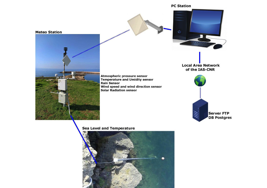
The station is connected to the intranet of the
Capo Granitola office via a radio link and via a
wired connection. A software in the Labview
environment has been developed to acquire data
from the weather station with a sampling rate of
one second, subsequently, at each minute the
average, maximum and minimum data are processed.
All the acquired data are saved both on .txt
files and inserted on DBMS postgres. Furthermore,
all the acquired data are sent to an FTP site at
the Department of the University of Malta.
The Figure 4 shows the operating diagram of the
CG SMM. Currently it is connected to a base
interrogation station, consisting of an Industrial
PC where software for querying parameters is
running. The two are connected through a radio
link, but a direct cable connection is also
provided, as soon as it becomes possible.
The upgrade of the station also consisted in the
creation of various ad hoc programs in the Labview
environment of National Instruments, for querying
the control unit, data acquisition, data
visualization, storage on DB SERVER at the
headquarters of Capo Granitola and the transfer
of data to the Ftp server of the University of
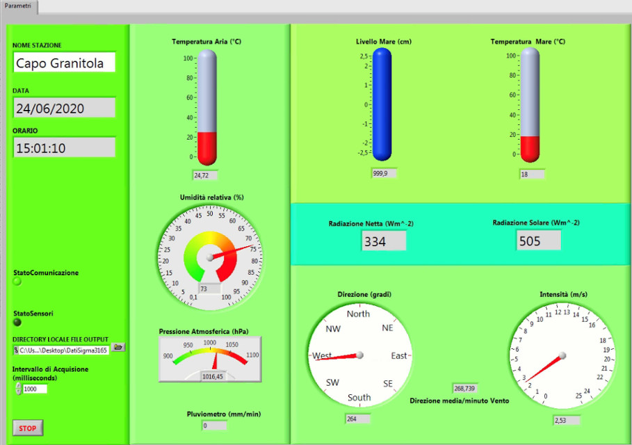
Malta (figure 5).
Figure 4: Operation diagram of the Meteo Marine Station of Capo Granitola.
Figure 5: Software interface for visualization of the meteo-marine
parameters acquired by the SMM of Capo Granitola