The deployment of the GPS directional wave buoy in Gozo
forms part of the NEWS (Nearshore hazard monitoring and
Early Warning System) project led by the Università degli
Studi di Enna “Kore”. The project is partially funded by
ERDF funds through the Italia-Mala Interreg V-A Operational
Programme (2014-2020). NEWS tackles the coastal erosion
risks on the southern coast of Sicily and the Maltese
Islands. Coasts are subjected to fast erosion due to
natural and anthropic causes which involve the failure
of cliffs, the triggering of localized erosions and the
possibility of flooding. NEWS deals primarily with the
modelling and monitoring of coastal risk processes,
including the design of alert components against major
risks. The system will make use of an integrated geophysical
sensor network on land as well as a networked set of wave
buoys installed offshore Sicily and the Maltese Islands.
The NEWS GPS wave buoy deployed in Malta resides at a
station offshore Marsalforn (Gozo). It measures sea waves
(height, direction and period) and sea temperature in real
time. A similar buoy makes the same observations on the
side of Sicily. The Malta buoy is maintained by the
Physical Oceanography Research Group
of the Dept. of Geosciences (University of Malta).
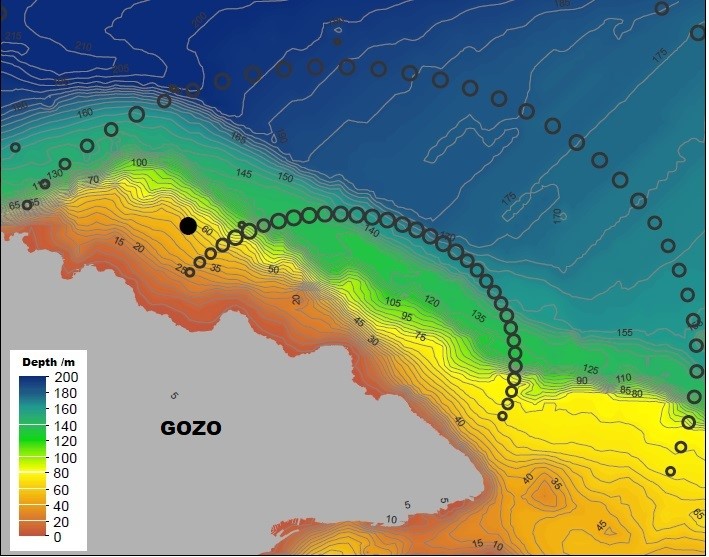
Figure 1: Station position of the wave buoy is
indicated by the black spot. Empty circles show
the annular wave bins measured by the HF radar
at SOPU station in Gozo. The background map shows
the sea depth contours in this marine area.
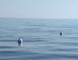
Figure 2: The GPS wave buoy on site.
The device itself is a small spherical (35cm diameter)
field serviceable buoy hull with electronics inside. The
station consists of a restrained shallow water near-coastal
system with a reference small yellow surface marker attached
to a subsurface mooring, to which the device is connected
by a 20m cord. The buoy moves over an area centred at
N 36° 04.882’; E 014° 16.875’ within a range of about 200m.
The heart of the buoy is the directional wave spectra sensor
which is a high-performance GPS engine paired with software
algorithms for onboard computation of the directional
wave spectrum with 1/256 Hz bandwidth from 0.03Hz – 0.50Hz
and a user programmable sampling window. On-board processing
enables the computation of the First-5 Directional Fourier
coefficients a0, a1, b1, a2, b2 that are used to compute
wave parameters such as significant wave height, swell
direction, and directional spread, among others. Sea Surface
Temperature is also measured with ±0.05K accuracy.
All measurements collected are logged onboard an optional
microSD card as well as relayed by satellite communication
to a land receiving station at the University of Malta
using Iridium Short Burst Data (SBD) telemetry.
The GPS wave buoy is a low cost new generation of wave
measuring devices. Traditional wave buoys are of the
gravity-acceleration-type, using a mounted acceleration
sensor, an electronic compass, a gyroscope to measure sea
waves based on the principle of gravity acceleration. The
GPS wave buoy is a new wave measurement method that uses
satellite GPS signals to measure ocean waves. It calculates
the movement velocity of the buoy using the Doppler
frequency shift of satellite GPS signals, which are then
used to calculate wave parameters. This makes the GPS wave
buoy a very versatile, small-sized device which only needs
a simple GPS sensor. Advantages over the
gravity-acceleration-type wave buoys are:
(i) no need of regular calibration since satellite
GPS signals do not further undergo measurement
errors due to increases in usage time,
(ii) measurements are not affected by any on-site
magnetic parts, and